Category: D-SAT
D-SAT new image downloaded

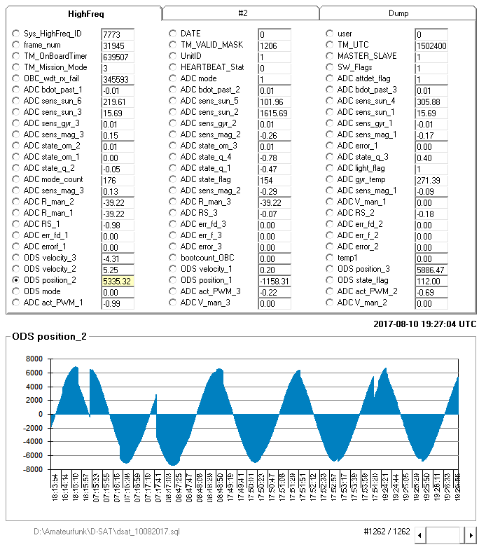
ADCS telemetry

D-SAT telemetry

D-SAT telemetry decoder
D-SAT was launched on June 23th, 2017 into a 500 km sun-synchronous orbit; before performing the final decommissioning maneuver it will host a few communication experiments in collaboration with an Italian university, high-level schools and a local hamradio community.
For more information on D-SAT, you can visit the mission’s website https://www.dsat.space. There is also a dedicated page for radiohams https://www.dsat.space/radiohams.

During this week they performed a SatAlert experiment that consist in the transmission of a “dummy” alert of a debris reentry.
Sae message saved to file Sae_msg_rcvd/sae_msg_rcvd_EPOCH_1500559064.sae

Message_type = 4

Protocol_version = 1

Print SAE MAMES

MessageID = 7

Alert ProviderId = 1

Notification Area Latitude, Nord-Sud = 0

Notification Area Latitude, deg = 45

Notification Area Latitude, min. = 37

Notification Area Latitude, sec. = 36

Notification Area Longitude, East-West = 0

Notification Area Longitude, deg = 36

Notification Area Longitude, min = 140

Notification Area Longitude, sec = 20

Notification Area Longitude, radius = 0

Message Priority = 15

NHT 1 = 4

Issuer = 3

Category = 0

NHT 2 = 1

Message Validity starts from  17/7/17 at 19:39:19

Message Validity ends at = 17/7/17  19:42:39

NHT 3 = 3

Language Id = 43

Message Length  = 321
The ALERT MESSAGE is:
AT 2:54 PM PDT...NATIONAL WEATHER SERVICE DOPPLER RADAR INDICATED
A SEVERE THUNDERSTORM OVER SOUTH CENTRAL ALPINE COUNTY...OR ABOUT 18 MILES SOUTHEAST OF
KIRKWOOD...MOVING SOUTHWEST AT 5 MPH. HAIL...INTENSE RAIN AND STRONG DAMAGING WINDS ARE LIKELY WITH THIS STORM
… and finally I could decode a nice image :-)

a stunning view of the Aegean Sea, Turkey on the bottom right corner, Crete in the bottom left and the Greek peninsula above
D-SAT Mission update
This was another good week for D-Sat: the team is keeping its health in check through different LEOP (Launch and Early Operations Phase) tests and they will soon start testing the GPS and calibrating its sensors.
Also, they were recently able to determine D-Sat’s NORAD catalog number, which means that now Radio Hams as well will be able to acquire its signal.
Last but definitively not least, D-Sat sent us another souvenir from Space: a picture of clouds over the Atlantic Ocean and the coast of England.
Just look at this…

As of for this week’s issue, we thought it would be fun to explore the topic of mobile technologies. Happy reading!
Ciao, until next time!
-The D-Sat Team
D-Sat CW Beacon
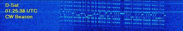
D-SAT CW beacon
11:24:25 UTC U1-DSAT-U1 8.16V

11:25:55 UTC U1-DSAT-U1 8.22V

11:27:25 UTC U1-DSAT-U1 8.22V

11:28:59 UTC U1-DSAT-U1 8.24V
D-SAT telemetry beacon
2017-06-23 10:14:26.100 UTC: [222 Bytes KISS Frame (without CRC)] ctrl: 124   PID: 7 {I36+}   196 Payload Bytes
   1 > 00 00 1B 07 00 00 02 01 00 01 FF 00 00 00 40 00 00 00 B6 04
  21 > A4 53 00 00 A4 53 00 00 02 02 07 00 02 66 F2 04 00 00 01 D9
  41 > 2C 3E DA 12 D5 E3 FE 75 FF 8A 01 9B 32 D1 96 09 A2 03 FF 07
  61 > 20 E7 CE D9 72 00 01 A8 07 5A 83 14 15 7E ED 49 0C 54 F0 91
  81 > 12 00 00 00 00 00 00 00 00 00 9D 27 44 00 00 00 00 00 00 00
 101 > 00 00 00 00 00 00 70 89 E6 22 0A 50 AF DC 5C 4E 04 48 E3 D5
 121 > 00 00 07 08 00 10 0A FE E9 FE FA 5C 86 91 A4 9C 8B 82 81 83
 141 > 81 82 82 08 82 01 00 00 C8 43 02 00 00 00 00 00 00 00 00 00
 161 > 05 00 01 00 00 00 06 07 09 07 07 03 01 00 00 00 00 00 00 00
 181 > 00 00 00 00 00 00 00 00 00 00 00 CF 00 00 01 E0